A Potential Way Forward on the Swan River Crossings Project
13 October 2022
There are lots of reasons to despair over the Fremantle bridge project and process.
But today I don’t want to dwell on the loss of heritage, a highway on a foreshore, or cut off access to parts of Fremantle.
Rather I want to focus on something potentially good, an unexpected opportunity that came out of my briefing by Main Roads last week.
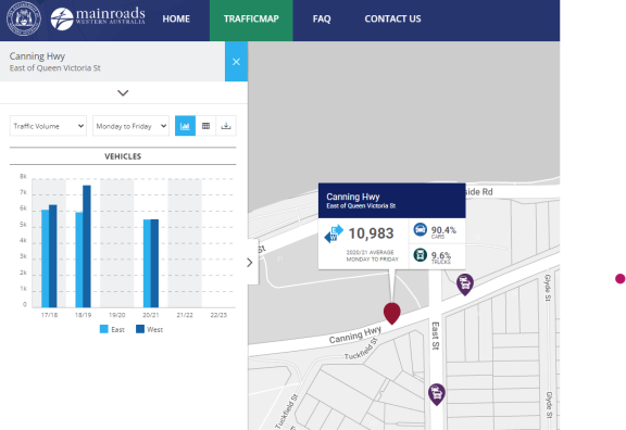
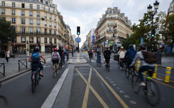
In the briefing when I suggested that reducing the east/west lanes in and out Fremantle from 6 down to 2 was not going to work well for 17, 000 vehicles a day that use it, I got an unexpected response: Our (Main Roads) traffic numbers are wrong. While their published data on trafficmap – Main Roads WA shows 10,981 vehicles per day on Canning Hwy and 6,190 on Beach Street, there are likely fewer cars using Canning Hwy than previously thought.
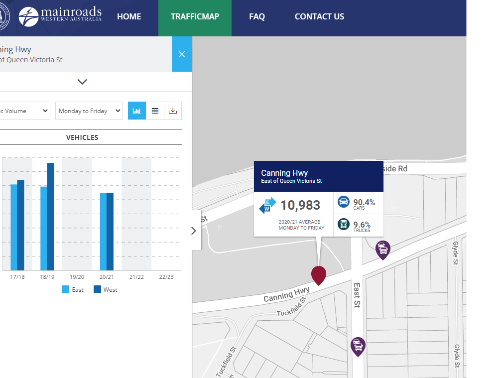
Putting aside that Main Roads are redesigning the Fremantle traffic network without knowing accurate numbers, if the west part of Canning Hwy has thousands of less vehicles than previously thought then this opens up the possibility of a traffic calmed and reduced sized Canning Hwy.
One key selling point for dropping Canning Hwy to the river was avoiding the horrific 8 lane wide intersection Main Roads were proposing just south of the new bridge.
But with substantially less cars you can leave Canning Hwy approximately where it is but reduce it to one lane in each direction. This would result in a smaller intersection which opens up options to still create a decent forecourt for the Navy Store – all while saving the beautiful cliffs, trees and foreshore.
This little insight was an expected upside of what has otherwise been a shambolic Main Roads process.
Once the community and Councils can move beyond the false choice between a highway under the bridge and a giant intersection, you never know, we might get a decent outcome yet.
Following the very sensible decision at last night’s Freo Council meeting, I’m pretty sure we can do better than this:
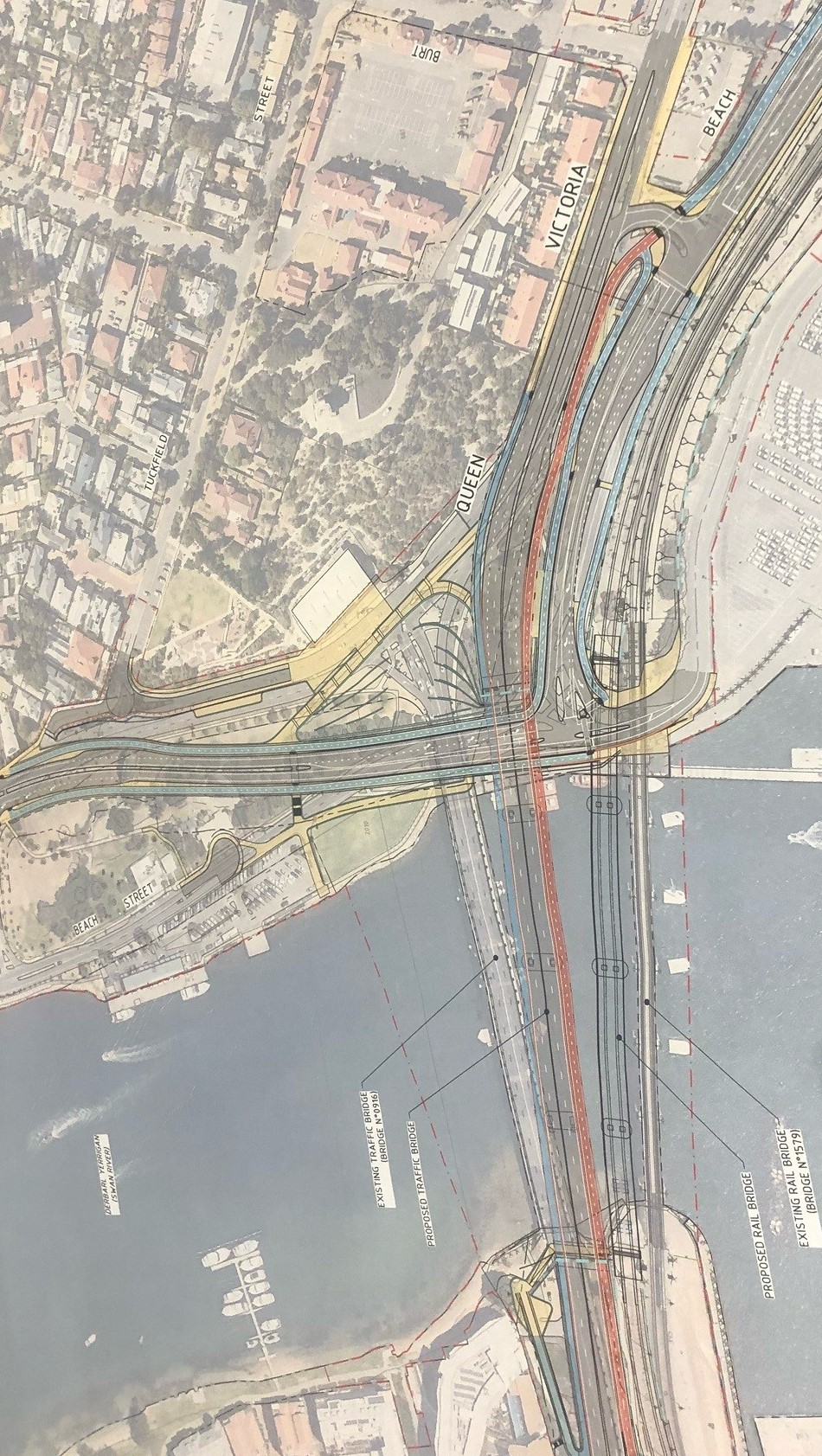
Main Roads Bridge Plan and road re-alignment
Why does every aerial picture of this project show 50m of the Northern abutment and a kilometre of the southern abutment and links.
I believe the aerials are continually portrayed this way so the future dire consequences for North Fremantle are masked. As a opponent of this wasteful expenditure from day 1, I’m appalled at how it is developing and I’ll never understand why the expenditure was welcomed by the COF and the elected State and Federal members back in 2019. At the time the response to opposition was “the project is replacing like for like”. Hardly!
There are so many better ways to improving traffic flows and crossings from the north to the south, yet the best route from 1939 is being replicated as the worst route 80 years on.
It’s astounding.
I agree there are better options. I think they should hold off until the future of the port is clearer and then do it once and do it right.
Agree completely. North Fremantle is completely ignored and the consequences for residents an businesses will be dire. There has been a woeful lack of consultation and the whole project has been run and designed (and I use that word very loosely) by engineers with no urban planning or big picture consideration whatsoever.
That’s Main Roads for you John. I just can’t understand why they are giving so much resources and have so much power to shape our urban environment. They should not be responsible for projects that are critical to our places.
Exactly. I walked a councillor around the area last week and Canning Highway there is not as busy as listed. Perhaps Canning Highway could cease at Stirling Highway and only a ‘local road’ of two lanes operate from then on, using East Street for access to the river and into Fremantle. Then Naval Stores get their forecourt and the escarpment remains unmolested by Main Roads.